Maungarei / Mount Wellington Domain
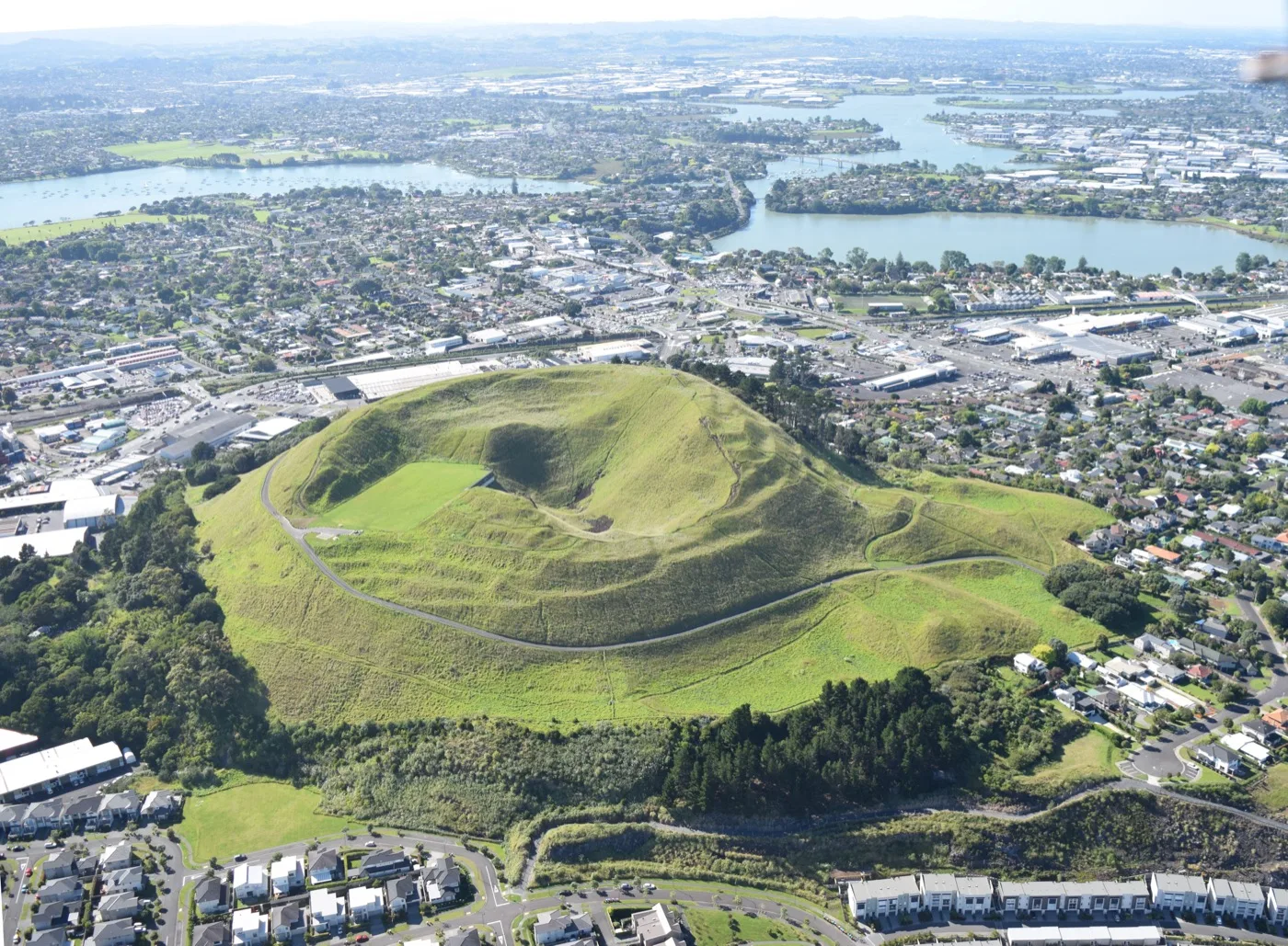
The youngest volcano on the Auckland mainland and one of its best-preserved pā landscapes. The terraced cone and craters are protected, with summit views reached on foot since the road closed in 2018.
From an eruption around ten thousand years ago, to one of Tāmaki Makaurau's great pā, to colonial farms, a vast quarry, and the Sylvia Park of today — the story of Mount Wellington and its maunga, Maungarei, runs deep.
Mount Wellington is a suburb defined by its maunga. Maungarei — the cone the colonial surveyors renamed Mount Wellington — is the youngest volcano on the Auckland mainland and the largest of the field's scoria cones. Around it sit layers of history: a great terraced pā, fertile market gardens, one of the country's biggest quarries, and, in our own time, New Zealand's largest shopping centre. This is how the area came to be what it is today. Where accounts differ — as they often do with deep history — we've said so.
Maungarei is a scoria cone in the Auckland Volcanic Field, generally dated to an eruption around 10,000 years ago. It is widely described as the youngest volcano on the Auckland mainland and the largest of the field's scoria cones. (Rangitoto, which erupted far more recently, sits offshore as an island — so Maungarei is best described as the youngest mainland cone rather than the youngest of all.)
The eruption built the cone from scoria — loose volcanic rock and cinder — and sent basaltic lava flows across the surrounding land, mainly to the west and south-west. One flow is recorded as running roughly six kilometres to the Manukau Harbour at Southdown; another blocked a valley to form the lake later known as Lake Waiatarua, or Lake St John. The cone has a near-circular base, a flattish rim and three small craters, and is most commonly cited as standing about 135 metres above sea level (sources differ slightly on the exact figure).

Maungarei was one of the great fortified pā of Tāmaki Makaurau and is described today as one of Auckland's best-preserved pā landscapes. Māori occupation of the maunga is generally traced to at least around 1400, while the visible terracing and storage-pit complex is usually attributed by archaeologists to the centuries that followed. The flanks — especially the eastern side — carry food-storage pits, terraced house sites, garden mounds and the remains of defensive ditches.
The name is best given as a tradition rather than a single fact: Maungarei is commonly translated as “the watchful mountain”, a reference to its commanding outlook, while the fuller form Te Maungarei a Pōtaka links it to an ancestor named Pōtaka. The volcanic soils and the two harbours close at hand made this a rich place to live and garden. Mana whenua connections to the maunga are today held collectively by Ngā Mana Whenua o Tāmaki Makaurau, a collective of 13 Auckland iwi and hapū; historical accounts particularly associate the nearby Tāmaki River settlements of Mokoia and Mauinaina, by present-day Panmure, with Ngāti Pāoa.
The European name was given by the surveyor Felton Mathew, who named the cone after Arthur Wellesley, the Duke of Wellington. The district sits beside the Tāmaki River, the tidal arm that historically served as a key route and portage between the Waitematā and the Hauraki Gulf side of the isthmus. Nearby Panmure was established as a fencible (military settler) village in the 1840s and 1850s, alongside Ōtāhuhu, Onehunga and Howick, and became the area's early commercial centre.
The fertile volcanic soils made Mount Wellington and the wider Tāmaki area a market-garden belt that supplied much of Auckland's vegetables well into the 20th century. The name “Sylvia Park” itself comes from a late-19th-century country estate — the residence and horse-breeding stud of Sir Maurice O'Rorke, a long-serving Speaker of the House. The champion racehorse Carbine is recorded as having been foaled at the Sylvia Park stud, which is remembered in nearby Carbine Road. (The site was a breeding stud, not a racecourse.)

Through the 20th century the basalt lava field around Maungarei was quarried intensively, chiefly by Winstone Ltd. The company's Mount Wellington — or Lunn Avenue — quarry opened in 1936, a few kilometres from the city centre, and grew into one of the country's largest, at its peak producing well over two million tonnes of aggregate a year. By the time the basalt resource was worked out around 2000, reporting indicates that tens of millions of tonnes had been extracted and used to build the roads and foundations of a growing Auckland.
It's worth being precise about what was quarried: the dramatic pit was carved largely from the surrounding lava field rather than the cone itself, although the lower south face of the maunga was also worked until 1967 before being revegetated. More broadly, quarrying reshaped the volcanic landscape of Tāmaki Makaurau over many decades — a significant and well-documented change to the region's maunga. When the Mount Wellington pit was exhausted, it was redeveloped from the 2000s into the residential neighbourhood now known as Stonefields.

After the Second World War, Mount Wellington changed from market gardens into part of Auckland's south-eastern industrial heartland and a major housing area. Flat land with rail and port access made the suburb and neighbouring Penrose attractive for industry, and through the 1950s tracts of state housing were laid out to house the workforce — which is why much of the suburb's residential stock dates from that era. Panmure was absorbed into Mount Wellington Borough in the mid-1950s.
The Sylvia Park land had a significant military chapter: from 1943 a large army supply-stores complex was built on the former stud land, used by the New Zealand Army until 1992, when it was sold and eventually became the shopping centre. Motorway-era infrastructure — State Highway 1 and the South-Eastern Highway interchanges — opened the area up to the rest of the city, accessibility that would later prove central to Sylvia Park's success.

The cone is now Maungarei / Mount Wellington Domain, a public reserve with one of Auckland's best-preserved pā landscapes and panoramic summit views. Under the 2014 Treaty of Waitangi settlement, Maungarei and 13 other Tūpuna Maunga were vested in Ngā Mana Whenua o Tāmaki Makaurau, and the maunga is co-governed by the Tūpuna Maunga o Tāmaki Makaurau Authority in partnership with Auckland Council. To protect its cultural and archaeological significance, the summit road was closed to private vehicles in December 2018 — the walk to the top is now on foot.
At the suburb's heart, Sylvia Park opened in 2006 on the old army-depot land and has grown into New Zealand's largest shopping centre, with its own railway station on the Eastern Line. Nearby, the Panmure Basin — a tidal lagoon in an explosion crater — offers a popular walkway, and the Stonefields community has risen from the former quarry floor. The AMETI Eastern Busway, with its new bridge across the Tāmaki River opened in 2021, is the area's defining current transport project. A young volcano, a great pā, a quarry and a shopping centre — all on the same patch of Auckland ground.

Drag the handle to fade between archival and modern Mount Wellington.
Circa 1860 engraving · 2018 aerial
1916 Lake St John · 2014 cone today

2008 quarry & early Stonefields · 2010 Sylvia Park interchange

Six places in modern Mount Wellington that still carry the past on the surface.
The youngest volcano on the Auckland mainland and one of its best-preserved pā landscapes. The terraced cone and craters are protected, with summit views reached on foot since the road closed in 2018.
New Zealand's largest shopping centre, opened in 2006 on the site of a former army supply depot — itself built on Sir Maurice O'Rorke's 19th-century Sylvia Park stud. It has its own Eastern Line station.
A tidal lagoon held within a volcanic explosion crater on the suburb's edge, ringed by a popular walkway and reserves — a reminder that Mount Wellington's landscape was shaped by more than one eruption.
A residential neighbourhood built from the 2000s on the floor of the exhausted Winstone quarry — the literal stone of which helped build much of modern Auckland.
The tidal arm along the suburb's eastern edge — historically a key Māori route and portage, and today crossed by the AMETI Eastern Busway bridge opened in 2021.
Winstone's quarry opened in 1936 and worked the lava field for decades. Its legacy is written across the suburb — in Stonefields, in the road network, and in the foundations of the wider city.
Every image on this page is used under a free or open licence with attribution. Tap any link to view the original record.
Historical detail draws on Wikipedia (Maungarei; Mount Wellington; Sylvia Park; Panmure; Eastern Busway), the Tūpuna Maunga o Tāmaki Makaurau Authority, and the Auckland History Initiative. Where sources differ or a fact rests on tradition, we've said so on purpose.
Leanne knows this suburb — its maunga, its school zones, its mix of older homes and new townhouses, and what buyers are actually paying around Sylvia Park and Stonefields today. Get a free, no-obligation appraisal from a specialist who works this market.
Book a free appraisal